
cazalea
[Seiko Moderator]
20995

Air Force Pilots; their watches and clocks, Part 1
In keeping with my earlier threads on Navy SEALs, this series of posts contains stories from USAF Fighter Pilot / Captain / Rolex Owner Morris B. Parker III.
(To us he's just Uncle Brownie):
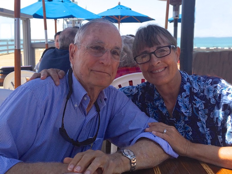
Here are a few of his tall tales, taken from his memoirs that I am editing and producing. Most of these stories occurred in the Fifties and Sixties. We'll start as he's learning to fly:
LEARNING TO FLY
Learning cross-country navigation was one of the skills we needed to master in Primary Flight School. Radio aids, which pilots constantly use to help them keep tabs on their position, were not allowed; it was all “dead reckoning.” I believe the proper spelling for that phrase is “de’d reckoning,” a contraction for “deduced reckoning.” With an E6-B circular slide rule we calculated the magnetic course we needed to fly on each leg of our flight, and also the time it would take to get from point A to point B. The proper solution always depends on the forecast winds you will be encountering en route, so a meteorologist was available to give us the wind speed and direction at the altitude of our flight.
With the instructor in the back seat I headed out for my first checkpoint, the little town of Wickenburg, Arizona. I think my instructor had flown this route so many times he was probably taking a nap in the back seat. Well, the clock was running down and I thought I saw Wickenburg on the horizon. The only problem was that it looked like I would be over the town about three minutes early. You have to understand, this little dude ranch town is all by itself out in the middle of the desert; nothing around for miles. But they had drummed into us:
“Compute the wind and airspeed, fly the corrected heading and airspeed, and then believe your clock!”
So I continued on my course another mile past town, straining my eyes to see if there happened to be another town immediately ahead of us that was somehow not on the map. Just as I about ready to admit defeat and make my turn to the next checkpoint a quiet voice from behind me said,
“Now, lieutenant, what do you suppose that was we just passed over?”
Me, timidly, “Wickenburg?” Instructor: “Riiiiight!” I got better at it. I had to get better at it because later on this would be the primary way we would navigate to our targets behind the Iron Curtain.
AERIAL PHOTOGRAPHY
My parents had given me a Kodak 35mm single-lens reflex camera when I left for flight training, the first of its kind. One of the great joys of life when I was flying single-engine airplanes was to come over the top of a loop, lay my head back, and watch the horizon slide into view. I thought how neat it would be if I could get a picture of that.
“Look Mom, this is what it’s like when you’re upside down!”
So with great effort I carefully balanced the camera on top of the glare shield with my left hand, my index finger on the shutter button, and with my right hand I guided the plane into a loop. As the horizon came into view at the top of the loop, I snapped the picture.
I turned in the negatives that very day, and then waited excitedly for the return of the developed pictures. I had to be patient as the exposed film was delivered to the laboratory in Tucson, developed, and returned to the base. Finally it arrived at the Base Exchange, and I anxiously thumbed through the prints until I found what I was looking for. There it was, only the desert was at the bottom and the sky was at the top! As I started to turn the photo upside down, it dawned on me…How dumb can I get?! If I wanted to show someone what it was like being upside down as you come through the top of the loop, all I had to do was to march up the stairs to the control tower, take a picture of the horizon and then turn the developed photo upside down. As the saying goes, “Too soon old, too late smart.”
MEMORIZATION
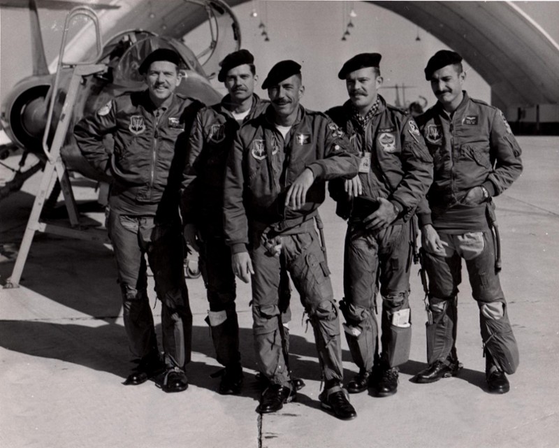
There is unending memory work in aviation, especially when it comes to emergency procedures. Every pilot is required to carry a condensed version of what he needs to do in case there is a system failure. Since this was before modern, computerized “glass cockpits,” single-engine pilots were given 5 x 8 inch spiral-bound checklists containing the various normal and emergency procedures. These checklists were clipped to a knee pad and strapped to the pilot’s leg. Critical emergencies require instant action and need to be memorized verbatim.
Notice lower leg pockets filled with note pads and such; ignore pilots attempting to appear French by wearing berets
Also in need of memorization was a long list of minutiae concerning aircraft limitations: airspeed, Mach and “G” load limitations for various flap, gear and external stores configurations, engine temperature and RPM limitations, minimum and maximum readings for oil and hydraulic temperatures and pressures, and many more. As with previous aircraft, before we could fly we were required to take a “blind cockpit check.”
Standing on the wing beside the student pilot, the instructor would ask him to close his eyes and then, one-by-one, touch the various instruments and switches in the cockpit. Looking back, I think it amounted to about forty or fifty different items. When pilots are assigned to check out in a new airplane, you will very often find them sitting in an empty cockpit memorizing the layout. As many items as there were to memorize, there was some kind of commonality in all the airplanes we flew, so that made it somewhat easier. None of us thought it was a particularly daunting thing to master; it just took a bit of time.
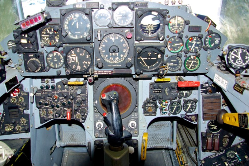
Cockpit of F-104; clock at far right
(this photo from the web)
NAVIGATION IN FRANCE
Our sole purpose for being in Europe was to deliver nuclear weapons if so ordered. The primary method of getting to the target was low-level navigation, thereby hoping to avoid detection by enemy radar. For safety purposes during practice, we were supposed to fly no lower than 500 feet above the ground, but most of the time it was more like 200 or 300 feet. I guess the French tired of our buzzing their chateaus and villas because a year after I arrived in France, their government canceled permission for us to practice this type of flying in their country. During that period of time, however, we had an enviable observation platform from which to see some of the many tourist attractions in northern France.
Our method of getting to the target is called point-to-point navigation. For training purposes, a fictitious target would be selected somewhere in our corner of France, perhaps a bridge over the Seine or a known abandoned airfield. We started off by determining what our arrival time would be over the target, taking into effect the quantity of fuel we carried. The fuel flow in a jet aircraft is always greater when you fly at a low altitude, and we had to have enough fuel to reach the target and return to home base.
We flew at 360 knots, or 415 statute miles per hour. A statute mile is what you have on the odometer of your car, so we were traveling 5-6 times faster than an automobile would typically drive on the motorway. The low-level portion to the target was usually about 45 minutes, which meant we flew about 300 miles en route to the target. Once our mission was completed, we turned home, climbing to a higher altitude to save fuel.
When we drew up our maps we were looking for easily recognizable landmarks 40 to 50 miles apart. A good landmark would be some salient feature such as a town with a cathedral on a hill, or a bridge over a river. The latter, I would find out by experience, could be a little tricky. The information on our maps was last updated prior to WWII, and many of those bridges were destroyed during the War and never rebuilt. So unless we had previous knowledge of the checkpoints along a route, we did not know what to expect.
The experienced pilot knew that instead of a bridge over a river, he might be seeing a long grassy ramp leading up to the river bank or perhaps some old wood pylons sticking out of the water. The time in minutes and the magnetic heading from one checkpoint to another were annotated on our maps, and the maps were attached to the clipboard strapped to our right thigh. Upon reaching a checkpoint, the pilot turned towards the next checkpoint and restarted the sweep second hand on the cockpit clock. If a particular leg was forty-eight nautical miles long, he would be looking for the checkpoint as he came up on the eight minute mark.
When a pilot is flying this kind of mission, his eyes are intermittently in the cockpit, glancing at the map and checking the heading, the airspeed, and the elapsed time. This means less time is spent visually clearing the airspace in front of him for traffic, so it is nice to have an extra pair of eyeballs checking for potential collisions. One time two of us blew right through an active French sailplane airstrip not marked on our maps. Thankfully, we managed to miss them all. This might have been one of the reasons low-level missions were canceled in France (shortly thereafter).
Thanks for reading. Please go on to Part 2 if you have time and interest.
Cazalea
Air Force Pilots; their watches and clocks, Part 1
In keeping with my earlier threads on Navy SEALs, this series of posts contains stories from USAF Fighter Pilot / Captain / Rolex Owner Morris B. Parker III. (To us he's just Uncle Brownie): Here are a few of his tall tales, taken from his memoirs that I ...
Air Force Pilots; their watches and clocks, Part 2
COMBAT READY IN GERMANY The entire 49th Tactical Fighter Wing was relocated from France to Spangdahlem, Germany in the summer of 1959. Before we could “sit alert” at Spangdahlem, we had to be certified Combat Ready. This meant we needed to possess in-dept...
Air Force Pilots; their watches and clocks, Part 3
REFUELING Rotations to Europe, along with Temporary Duty Assignments to Alaska, required our pilots to fly long distances, far beyond the normal range of any fighter aircraft. When we were fitted with four external fuel tanks under our wings—our maximum l...
Air Force Pilots; their watches and clocks, Part 4
COMBAT IN VIET NAM Our group only had one sortie north of the DMZ. The target was about 75 miles north of Da Nang and about five miles inland from the Gulf. The intelligence officer showed us a picture taken by a photo reconnaissance plane. It was strange...


F-104 Lawn Dart
cazalea Thanks for the high angel tales. Your friend is lucky to survive the infamous Lawn Dart that is the Starfighter. Stubby wings and high wing-load, high stall speed and crazy landing speed, vibration prone nose wheel. Some air forces lost a quarter ...

The "Widow Maker" was mostly a German problem ...
... since the Starfighter was transformed into something that it never was intended to be: What was designed as a super-sonic daylight interceptor with the task to attack enemy bombers at high altitude in a single, high speed pass, found itself in the rol...
I asked Brownie about this last night
Thanks for the observations Marcus. They are consistent with what i have read. Capt Parker said that some forces (including the USA) put men in planes, in combat during WW II, with as few as 70 hours total flying experience! They certainly couldn't do tha...

When I was in Bahrain in the mid-'80s . . .
. . . a resident Jordanian lawyer I met at a party made a scathing comment about the Widow-maker. It was only later that it dawned on me he might've had a personal connection to one of the many Jordanian pilots who lost their lives flying the F-104. Wistf...
The leading edges were so sharp ...
... that on ground, thick protectors had to be mounted in order to prevent the ground crew from being hurt when hitting the edges. I love that plane, and still have three unbuilt model kits from 1/72 to 1/32 hidden in that infamous closet since a decade o...
Memo to myself: read posts first ...
... just saw that you mentioned this in your excellent writeup ... Marcus
Just build two; hold one in each hand, and whirl around in your room
like boys everywhere, having fun flying your models! NASA's beautiful "hot rodded" F-104 Cazalea ...
I've got decals for that one, I think! ...
... but I fear the modifications necessary are more than I want to do. Marcus

Wow this is very interesting!
I only read the first part. Will return to slowly read and appreciate the rest. Maybe I will end up hunting for a pilot watch even though I can never be a pilot! (I fear heights ... A lot !) Cheers Robin
Air Force Pilots; their watches and clocks, Part 5
Hello flight-loving PuristS, Here's a bit more about Capt. Brownie Parker's flying experiences in the USAF in the 1950's and 1960's: THE F-104 STARFIGHTER The F-104 Starfighter was designed by Clarence “Kelly” Johnson, unarguably the most talented aeronau...

These guys are so cool. It was another era.
Going back for a more complete read. Thanks for the great contribution as always. Bill
What an amazing read !.. Love your topic & the tales from times, long gone.. Thx so much for these comprehensive posts !.. :))
PS: will come back & read the other parts, and then bookmark them ! Real reading pleasure ! Best, hs

Thank you all for reading and for responding - I'll try to find a few more
stories that justify another episode. Remembering the lives of those who went before us and those who are still with us is a worthwhile endeavor. Cazalea ...
Air Force Pilots; their watches and clocks, Part 6
Please rejoin me for a few more stories about flying an F-104 around Europe in the 1960's: HOW SLOWLY CAN YOU FLY? On two occasions we were involved in war games with the Navy’s Sixth Fleet in the Mediterranean Sea. The Navy thought if they maintained rad...
The story about the "Tante Ju" bombing the 6th Fleet is hilarious! ...
... I think I need that book! Marcus